
Every Picture Tells A Story
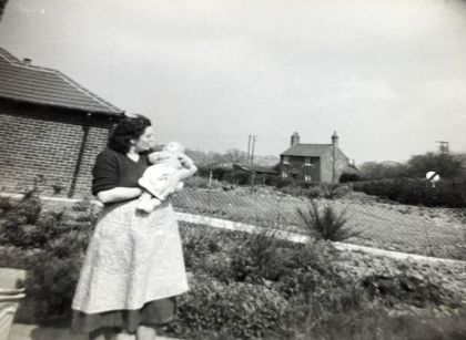
Do you recognise where this is in Newbold Verdon? No? Well, you are not alone.
Since having this sent to us last year, no one who has seen it has been able to identify the location, until a few clues were offered, so here they are for you.
Still none the wiser, or have you worked it out?
You are looking at a picture taken at the end of Dragon Lane on the opposite side of the road to the doctors’ surgery. Your view today would be blocked by a row of houses built on the site where the bungalow once stood, until, that is, mining subsidence brought it down. The culprit was the Merrylees Drift Mine’s coalface. Lying only 300 feet below the surface, it was responsible for a great deal of damage done to buildings in Barlestone, Newbold and Newbold Heath. The old house in the picture was also a victim of the mine.
A few may remember it as the tollgate house. It was the home of those employed to take the tolls from travellers on the Foston Turnpike. Constructed in the late 18th century, the 15 mile turnpike ran the full length of what is now the B582 from Osbaston Crossroads to Foston on the eastern side of Countesthorpe. Two gates stood across the road, one to Barlestone and the second to Market Bosworth.
The baby in the picture is the person who donated it to the Archive !
What The Community Has Told Us
Update: When this article was shared on our Facebook page, it prompted a lively conversation about what mining left behind. These are recollections rather than documented facts, and we would love to hear whether others remember things the same way.
Subsidence and rebuilding. One reader recalled that not all of the old workings were filled in, so ground movement has continued in parts of the village. They had heard that some houses were built on what were called “floating bases”, designed so that a house would stay up if the land moved beneath it. The idea did not work as hoped, and the houses had to be taken down and rebuilt in a different way.
“Crash packing”. A reader whose father worked at Merrylees pit explained that, rather than being filled, the workings were often left to collapse once the pit props were taken out, a method known as “crash packing”. In his account, this is why roads around the Leicestershire mining villages rise and fall like “big dippers” and why so many houses have subsided.
Closing the pits. One contributor, whose great-grandfather was among those who began the digging of Desford Pit, recalled that when the pit was closed its entrance was filled in, and that the miners’ lamps still held in the pit were thrown down the shaft before it was sealed. A member of the family who witnessed it was dismayed by this.
Dragon Lane. Another reader remembered that the old mine was always given as a reason not to build behind Dragon Lane.
Sights and sounds of the mining village. One reader remembered looking out from the top of Sparkenhoe as a child and seeing the pyramid-shaped slag heaps at Bagworth, and hearing the Merrylees pit siren in the early morning. Looking in the same direction today, they now see a large wind turbine. Another recalled their father, a mine worker, who during his lunch breaks made small models, including dogs’ heads, from material found on the heaps.
Family connections. One contributor’s grandfather was the Leicestershire miners’ union representative and was awarded the MBE for his work. Others spoke of fathers and grandfathers who worked at Merrylees and Desford, a reminder of how closely mining shaped village families.
With thanks to our Facebook followers for sharing their memories and family stories.
If you have any photographs that you feel tell a story of the history of the village and parish, why not us our contact form HERE and drop us a line.
